
I’ve spent a lot of time pondering ways to share and sort information by locality. I’ve had so many questions about places. For example, there is a church on highway 47, almost seven miles east of Chase City, that has a Chase City address. But there’s a VDOT sign near the church that says Drapersville. Which place name would help people find that church? Which place name would locals associate with the church? What place name would people associate with that church who have never been to Mecklenburg, and have only looked at maps?

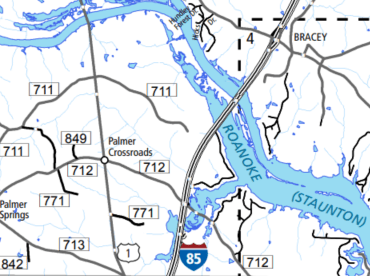
I want to know things like, why does Google maps list rural place names without reference to the county? Like “Invermay, Virginia”, or “Antlers, Virginia”. Both places used to have post offices in Mecklenburg County, but they haven’t had post offices for decades. I also wonder if the name Palmer Springs changed to Palmer Crossroads? Or is Palmer Crossroads the name of the intersection and Palmer Springs the name of the area? If so, why is Palmer Crossroads what shows up on maps now? The same questions apply to Hanford and Hanford Crossroads.
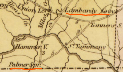

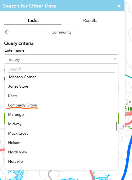
I also wondered how I should refer to old places like Lombardy Grove. It was a place referenced in older court records. It used to be a busy place on a major crossroads connecting towns in Mecklenburg County with major routes to the Roanoke River and Petersburg. The roads leading east & west from Lombardy Grove don’t exist anymore and I didn’t think Lombardy Grove exists as an area anymore either. The railroads, followed by the highways, went through the old Lombardy Grove area. I have not seen a VDOT sign for Lombardy Grove and it is not marked on maps I’ve seen dated between 1890-2021. I was surprised to see “Lombardy Grove” on the latest VDOT map. It is not visible as a place on the county GIS map, but I did find it listed under “community”.
I thought about trying to group information by post offices, but that gets complicated and confusing. A church that looks to me to be located between Bracey and Palmer Springs has a South Hill address. A house on Nellie Jones Rd in Bracey could have been labeled as being the 98th Regiment, Tanner’s Store, Boydton, South Hill, La Crosse, and Bracey. It all depends on what time period each post office serviced that area. I’ve been researching the history of post offices in Mecklenburg County. I counted all the different place names on Mecklenburg County GIS, USGS maps, old post office maps, and old post office contracts. I currently know of 137 place names in the county! I have found 97 of those 137 place names on post office maps and in post office contract records. I’m still looking through a post office record collection, to see if any of the other 40 place names were also old post offices. I have listed some place names on this places page to show which post office currently services those old post office areas. I felt that 97 post office places was way too many places to use for the purpose of organizing this website. If I only picked a few of them, what criteria would I use? Organizing by only using the eleven present day post offices didn’t seem like it would be enough, especially in the center of the county, or when trying to include places that don’t exist anymore.
My husband pointed out to me that most of my questions revolved around trying to define a rural place. But there isn’t any set standard for defining rural areas. Independent cities, counties and towns have clearly defined areas. “Non-incorporated communities” and large farming areas do not have defined areas. I decided that the solution to my challenge, was to designate my own clearly defined areas, according to boundaries that make sense to me, to make it easier to organize information on this website. For instance, if I call something “area 12”, I can show all the place names within that defined area (area 12), past or present.
I have broken up the county map into 29 areas. (see image at the bottom of this page). I am in the process of creating a “place page” for each of the areas. On these pages, I will list all the post offices, churches, old rural schools, and any other public building of each area on those “place pages”. I will also list surnames from that area (from cemeteries, deeds etc), posts from this site pertaining to the area, and cemeteries for that area. I will also list names of churches and cemeteries as people tell me the information, even if I do not yet have pictures or any further information. The separate Churches Page and Cemetery Pages will also be organized by these 29 areas. I have started a places tab at the top of the website.

I am still writing up area descriptions as part of the collaborative map and for the website. Place descriptions will be at the top of each numbered place page, on the website. That same description will be included in the information box of each area on the map, as shown below.
Here is an example of area 1, the northwest corner of the county:

This map allows you to type in the search box to search for a specific pin. Or, as shown above, you can click on an item in the list to see the corresponding pin or area. The example shown above, was made visible by clicking on “1” in the list.
“Area 1” includes Black Branch Baptist Church and the old Finneywood post office. I visited Berean church last year. The church and the cemetery beside the church would be in area 2. There is also a cemetery on the west side of Highway 49, across the street from the church. The cemetery across the street is part of area 1. I will make a notation in both area 1 and area 2 that there are tombstones on both sides of the road.
I looked at VDOT’s designated areas of towns and the Bracey area on this map of Mecklenburg County. I drew the same boundary areas on the Collaborative map for this website in red. The insert map areas are a little larger than the squares on the full map. I drew lines to correspond with the full sized map. (not map A). Note: Bracey is not an incorporated town, but it does have a defined area on this VDOT map.

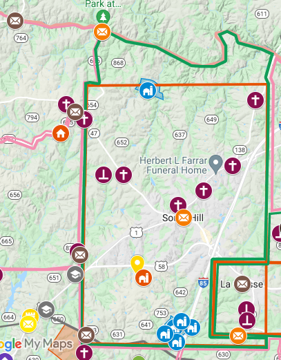
The tall red rectangle below is the defined area of South Hill. There was a small area between the northern boundary of South Hill and the northern boundary of the county. (the Meherrin River) The green outline is the area I extended outside the defined boundaries of a town, to be included with the town, for the purpose of organizing on this website.
The collaborative map on this website is where I mark GPS pins from my visits. I drew the area boundaries on this map in a new layer. This way, I can easily see which area a pin is placed, because everything is marked on the same map. The red and white numbers are not visible on the collaborative map. I added those numbers to the map in Photoshop. The red numbers represent towns.
My collaborative map now has 10 layers. You can click the boxes to add or remove layers from visibility. The first layer is the 29 area divisions. The next layer is churches and cemeteries. Each color is a different time period: Purple, yellow, orange, blue and gray. The next layer is: post offices, county boundary lines, and some rods and poles measurements for large plats. The next layer is creeks (light green) and some public buildings after 1920 (gray), like present day schools. The last layer shows the old 98th Regiment shaded gray. The 22nd Regiment is the area not colored or shaded.
Drapersville is listed as “Drapersville, Virginia 23924” on Google maps, which is a Chase City zip code. My new method of organizing by area, places the Drapersville street sign on the boundary of areas 2 & 3. The sign is on the east side of Old Cox Rd, so the Drapersville sign in area 3.
I hope organizing this website by 29 defined place areas will be helpful to you in your Mecklenburg County research!


Leave a comment